
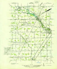
1936 Map of Rockwood
USGS Topo · Published 1936About this map
The Detroit River serves as a busy maritime corridor in the late 1930s, featuring the Livingstone Channel and Amherstburg Channel along the international boundary with Canada. On the American side, Grosse Ile is a focal point of development and defense, hosting the U S Naval Reserve Aviation Base alongside the Grosse Ile Golf and Country Club. The map detail shows the transition from industrial waterfronts near Trenton and Gibraltar to the marshy lowlands of the Lake Erie shoreline.
Find a feature on this map
81 named features on this map. Tap any name to fly to it.
Don’t see what you’re looking for? This feature index may not catch every label — zoom into the map to look around manually.
Map Details
Editions of this 1936 Rockwood Map
This is the sole edition of this map. No revisions or reprints were ever made.
Other maps of this area

1906 · Wyandotte
USGS Topo · 1:62,500

1906 · Romulus
USGS Topo · 1:62,500

1912 · Wyandotte
USGS Topo · 1:62,500

1912 · Monroe
USGS Topo · 1:62,500

1914 · Monroe
USGS Topo · 1:62,500

1928 · Romulus
USGS Topo · 1:62,500

1929 · Wyandotte
USGS Topo · 1:62,500

1936 · Wyandotte
USGS Topo · 1:31,680

1936 · Stony Point
USGS Topo · 1:31,680
1936 · Flat Rock
USGS Topo · 1:31,680