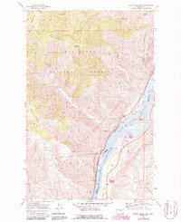
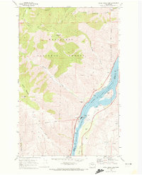
1968 Map of Rocky Reach Dam
USGS Topo · Published 1987About this map
Rocky Reach Dam dominates this section of the river, where the Columbia River Lake Entiat is held back by the massive powerhouse and fish ladder structures. The industrial footprint of the dam is meticulously detailed, showing a spawning run, pumping station, and a fish holding pond designed to manage local salmon populations after the river was harnessed. On the western bank, the Burlington Northern railroad follows the shoreline through a landscape of sharp relief defined by the Entiat Mountains and Burch Mountain.
Find a feature on this map
37 named features on this map. Tap any name to fly to it.
Don’t see what you’re looking for? This feature index may not catch every label — zoom into the map to look around manually.
Map Details
Editions of this 1968 Rocky Reach Dam Map
2 editions found
Other maps of this area

1901 · Chelan
USGS Topo · 1:125,000

1912 · Malaga
USGS Topo · 1:48,000

1913 · Wenatchee
USGS Topo · 1:62,500

1914 · Malaga
USGS Topo · 1:62,500

1915 · Wenatchee
USGS Topo · 1:62,500

1920 · Colockum Pass
USGS Topo · 1:125,000

1922 · Colockum Pass
USGS Topo · 1:125,000

1957 · Wenatchee
USGS Topo · 1:250,000

1966 · Rock Island
USGS Topo · 1:24,000

1966 · Wenatchee
USGS Topo · 1:24,000