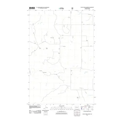
2011 Map of Rocky Ridge North
USGS Topo · Published 2011About this map
The Rocky Ridge landscape in Slope County is defined by a series of prominent high points and a network of named family ranches that anchor the local geography. Scattered across the terrain are distinctive landmarks such as Flat Top Butte, Windy Butte, and Chocolate Butte, which break the horizon between the grazing lands. This survey captures a region of western North Dakota where transportation and water dictate the layout of the land. Davis Creek and Third Creek flow through the western sections, while the South Branch Heart River enters at the northeast, and Adobe Wall Creek marks the southeastern reach. A series of long-standing family operations, including the Hewson Ranch, Fugere Ranch, and L Fritz Ranch, are connected by a grid of rural roads like 134th Ave S W and the descriptively named Burning Coal Vein Rd, reflecting the area's geological and ranching history.
Find a feature on this map
29 named features on this map. Tap any name to fly to it.
Don’t see what you’re looking for? This feature index may not catch every label — zoom into the map to look around manually.
Map Details
Editions of this 2011 Rocky Ridge North Map
This is the sole edition of this map. No revisions or reprints were ever made.
Other maps of this area

1953 · Dickinson
USGS Topo · 1:250,000

1957 · Dickinson
USGS Topo · 1:250,000

1961 · Daglum
USGS Topo · 1:62,500

1961 · Rocky Ridge
USGS Topo · 1:62,500

1962 · Tracy Mountain
USGS Topo · 1:24,000

1962 · Belfield SW
USGS Topo · 1:24,000

1962 · Fryburg
USGS Topo · 1:24,000

1980 · Belfield
USGS Topo · 1:100,000
1982 · Daglum NW
USGS Topo · 1:24,000
1982 · Daglum SW
USGS Topo · 1:24,000