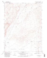
1968 Map of Rodeo Creek NW
USGS Topo · Published 1986About this map
Boulder Valley defines the lower elevations of this high-desert landscape, where ranching and resource extraction converge at the border of Elko and Eureka counties. The presence of Boulder Windmill Corral and Sheep Creek Windmill Corral indicates a managed livestock economy dependent on dispersed water sources, while scattered Gravel Pits and a Prospect suggest the early stages of mineral exploration common to the region in the late 1960s. Terrain transitions sharply from the valley floor to the rising slopes of the Sheep Creek Range. This 1968 field-checked survey also documents modern infrastructure developments in the remote basin, including a notable Aqueduct and Water Tank network at the foot of the mountains. Several drainage systems, including Rodeo Creek, Bell Creek, and Boulder Creek, carve through the complex topography, providing natural corridors through the high country alongside several marked private roads and a Jeep Trail.
Find a feature on this map
29 named features on this map. Tap any name to fly to it.
Don’t see what you’re looking for? This feature index may not catch every label — zoom into the map to look around manually.
Map Details
Editions of this 1968 Rodeo Creek NW Map
3 editions found

Other maps of this area

1955 · McDermitt
USGS Topo · 1:250,000

1955 · Winnemucca
USGS Topo · 1:250,000

1958 · Winnemucca
USGS Topo · 1:250,000

1959 · McDermitt
USGS Topo · 1:250,000

1962 · Winnemucca
USGS Topo · 1:250,000

1965 · Sheep Creek Range NE
USGS Topo · 1:24,000

1965 · Sheep Creek Range SE
USGS Topo · 1:24,000
1965 · Willow Creek Reservoir SE
USGS Topo · 1:24,000

1968 · Rodeo Creek SW
USGS Topo · 1:24,000

1968 · Rodeo Creek NE
USGS Topo · 1:24,000