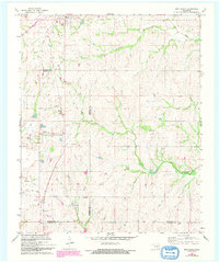
1967 Map of Roff South
USGS Topo · Published 1993About this map
The Blue River and its tributaries carve a complex drainage pattern across this landscape where the borders of Pontotoc, Murray, and Johnston counties converge. Settlement is concentrated around Roff in the north and the small community of Hickory to the west, which is served by the Hickory Cem. The southern reach of the map features Winrock Farms and the Scullin area, where an Old RR Grade hints at former rail connections through the region. Industrial activity is evident through various extraction sites, including Sandpits near Dennis and several gravel pits scattered along the creek beds. Large-scale land use is further represented by the Horseshoe Ranch and the Roos Landing Strip, illustrating the mix of ranching, local aviation, and resource extraction that defined this portion of Oklahoma during the mid-to-late twentieth century.
Find a feature on this map
26 named features on this map. Tap any name to fly to it.
Don’t see what you’re looking for? This feature index may not catch every label — zoom into the map to look around manually.
Map Details
Editions of this 1967 Roff South Map
3 editions found
Other maps of this area

1901 · Stonewall
USGS Topo · 1:125,000

1901 · Tishomingo
USGS Topo · 1:125,000

1957 · Ardmore
USGS Topo · 1:250,000

1963 · Ardmore
USGS Topo · 1:250,000

1963 · Sulphur South
USGS Topo · 1:24,000

1963 · Mill Creek
USGS Topo · 1:24,000

1967 · Roff South
USGS Topo · 1:24,000

1967 · Ahloso
USGS Topo · 1:24,000

1967 · Connerville
USGS Topo · 1:24,000

1967 · Roff North
USGS Topo · 1:24,000