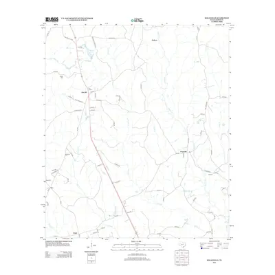
2012 Map of Roganville
USGS Topo · Published 2012About this map
Roganville and the surrounding piney woods of Jasper County are documented here in detail during the early 21st century. The landscape is defined by a dense network of county roads and creek drainages that supported a timber-based economy for generations. Small, localized settlements such as Erin, Zion Hill, and Keithton are scattered across the terrain, often centered near local landmarks like Zion Lookout or water sources such as Big Cr and Marshall Lake. For those researching local families, the map identifies several rural burial grounds, including McLemore Cem, Boyett Cem, and Kyle Cem. The road network is particularly intricate here, showing the evolution from the Old Kirbyville Hwy to modern routes like FM-1005 and FM-252, which link the smaller hamlets like Eclipse to the larger region.
Find a feature on this map
74 named features on this map. Tap any name to fly to it.
Don’t see what you’re looking for? This feature index may not catch every label — zoom into the map to look around manually.
Map Details
Editions of this 2012 Roganville Map
This is the sole edition of this map. No revisions or reprints were ever made.
Other maps of this area

1952 · Lake Charles
USGS Topo · 1:250,000

1954 · Lake Charles
USGS Topo · 1:250,000

1954 · Beaumont
USGS Topo · 1:250,000

1955 · Roganville
USGS Topo · 1:62,500

1955 · Curtis
USGS Topo · 1:62,500

1957 · Beaumont
USGS Topo · 1:250,000

1958 · Spurger
USGS Topo · 1:62,500

1958 · Kirbyville
USGS Topo · 1:62,500

1984 · Beaumont
USGS Topo · 1:250,000
1984 · Jamestown
USGS Topo · 1:24,000