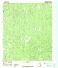
1984 Map of Jamestown
USGS Topo · Published 1985About this map
Jamestown and the neighboring settlement of Farrsville anchor this 1980s landscape on the border of Jasper and Newton counties. The area is defined by a dense network of watercourses, including the meandering Big Cow Creek and its many tributaries like Lewis Gully and Hunter Creek. An Old Railroad Grade cuts across the northern terrain, indicating a history of timber or industrial transport that once serviced this part of East Texas. Small clearings for homesites and several Cemeteries are scattered throughout the wooded basins near Melhomes, offering specific points of interest for genealogists tracing family land in the region. The map also captures the confluence of numerous branches, such as Blue Branch, Huff Creek, and Irving Branch, which feed into the larger creek systems that have shaped the local topography and settlement patterns for generations.
Find a feature on this map
21 named features on this map. Tap any name to fly to it.
Don’t see what you’re looking for? This feature index may not catch every label — zoom into the map to look around manually.
Map Details
Editions of this 1984 Jamestown Map
This is the sole edition of this map. No revisions or reprints were ever made.
Other maps of this area

1944 · Wiergate
USGS Topo · 1:62,500

1948 · Wiergate
USGS Topo · 1:62,500

1952 · Lake Charles
USGS Topo · 1:250,000

1953 · Alexandria
USGS Topo · 1:250,000

1954 · Wiergate
USGS Topo · 1:24,000

1954 · Wiergate
USGS Topo · 1:62,500

1954 · Lake Charles
USGS Topo · 1:250,000

1955 · Alexandria
USGS Topo · 1:250,000

1955 · Roganville
USGS Topo · 1:62,500

1957 · Brookeland
USGS Topo · 1:62,500