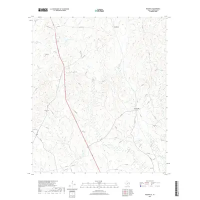
2019 Map of Roganville
USGS Topo · Published 2019About this map
Roganville and the surrounding piney woods of Jasper County are defined by a network of small creeks and rural connectors. The landscape is carved by watercourses like Thickety Cr and Everett Cr, which feed into the broader regional drainage system. The settlement pattern here is sparse, with small communities such as Erin and Keithton linked by a web of county roads and the Old Kirbyville Hwy. Grounded in local heritage, the map identifies several family-named landmarks and burial sites, including McLemore Cem and Boyett Cem, which offer significant value for genealogical research in this part of East Texas. Notable landmarks such as Bald Hill and the waters of Marshall Lake break the terrain, while the inclusion of the Very Simms Huntin Club highlights the area's long-standing recreational and timber-land use.
Find a feature on this map
58 named features on this map. Tap any name to fly to it.
Don’t see what you’re looking for? This feature index may not catch every label — zoom into the map to look around manually.
Map Details
Editions of this 2019 Roganville Map
This is the sole edition of this map. No revisions or reprints were ever made.
Other maps of this area

1952 · Lake Charles
USGS Topo · 1:250,000

1954 · Lake Charles
USGS Topo · 1:250,000

1954 · Beaumont
USGS Topo · 1:250,000

1955 · Roganville
USGS Topo · 1:62,500

1955 · Curtis
USGS Topo · 1:62,500

1957 · Beaumont
USGS Topo · 1:250,000

1958 · Spurger
USGS Topo · 1:62,500

1958 · Kirbyville
USGS Topo · 1:62,500

1984 · Beaumont
USGS Topo · 1:250,000
1984 · Jamestown
USGS Topo · 1:24,000