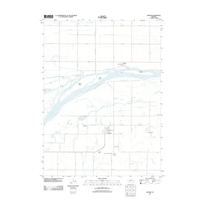
2011 Map of Rogers
USGS Topo · Published 2011About this map
Linwood and Rogers anchor this section of the Platte River valley, where the waterway divides around large landmasses like School Island, Sheep Island, and Murphy Island. The landscape south of the river is defined by the sharp rise of Indian Hill and Linwood Hill, overlooking the confluence of Skull Creek and Duck Creek. This 2011 survey captures the area's agricultural and social infrastructure, from the Byrne Ditch irrigation system in the north to the cluster of community sites around Linwood, including the Linwood Post Office, Saint Marys Cemetery, and Linwood Cemetery. Further south, the wooded terrain near Sand Creek is home to Camp Moses Merrill, while the northern portion of the map shows the village of Rogers situated along the primary east-west transportation corridor. Local history is preserved in landmarks like Dawson Cemetery and the small riverside settlement of Riverside Acres.
Find a feature on this map
53 named features on this map. Tap any name to fly to it.
Don’t see what you’re looking for? This feature index may not catch every label — zoom into the map to look around manually.
Map Details
Editions of this 2011 Rogers Map
This is the sole edition of this map. No revisions or reprints were ever made.
Other maps of this area

1899 · Wahoo
USGS Topo · 1:125,000

1899 · David City
USGS Topo · 1:125,000

1955 · Fremont
USGS Topo · 1:250,000

1957 · Fremont
USGS Topo · 1:250,000

1958 · Fremont
USGS Topo · 1:250,000

1966 · Webster
USGS Topo · 1:24,000

1966 · Dodge SW
USGS Topo · 1:24,000
1966 · Clarkson SE
USGS Topo · 1:24,000

1968 · Bruno
USGS Topo · 1:24,000
1968 · Schuyler
USGS Topo · 1:24,000