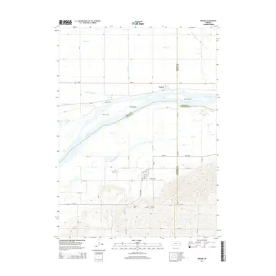
2014 Map of Rogers
USGS Topo · Published 2014About this map
The Platte River corridor dominates this landscape, carving through the central portion of the map and creating a network of river-formed features like School Island, Sheep Island, and Murphy Island. To the north, the small settlement of Rogers sits along Us-30, surrounded by an intricate system of agricultural drainage including Byrne Ditch and O'Hare Ditch. South of the river, the terrain rises sharply from the floodplain toward Indian Hill, where the town of Linwood is located. This area is particularly rich in genealogical data, containing several burial sites such as Dawson Cem, Saint Marys Cem, and Linwood Hill Cem. The southern half of the map is defined by the winding paths of Skull Cr and Duck Cr as they move toward the Platte valley, illustrating the transition from upland prairie to the fertile river bottomlands of east-central Nebraska.
Find a feature on this map
47 named features on this map. Tap any name to fly to it.
Don’t see what you’re looking for? This feature index may not catch every label — zoom into the map to look around manually.
Map Details
Editions of this 2014 Rogers Map
This is the sole edition of this map. No revisions or reprints were ever made.
Other maps of this area

1899 · Wahoo
USGS Topo · 1:125,000

1899 · David City
USGS Topo · 1:125,000

1955 · Fremont
USGS Topo · 1:250,000

1957 · Fremont
USGS Topo · 1:250,000

1958 · Fremont
USGS Topo · 1:250,000

1966 · Webster
USGS Topo · 1:24,000

1966 · Dodge SW
USGS Topo · 1:24,000
1966 · Clarkson SE
USGS Topo · 1:24,000

1968 · Bruno
USGS Topo · 1:24,000
1968 · Schuyler
USGS Topo · 1:24,000