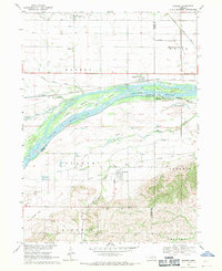
1968 Map of Rogers
USGS Topo · Published 1971About this map
The Platte River corridor dominates this late-1960s landscape, weaving a complex network of channels and landforms including Sheep Island and Murphy Island. The settlement of Rogers sits north of the river along the Union Pacific line, while Linwood occupies the southern bluffs near the mouth of Skull Creek. This survey captures the transition from the flat, ditch-drained agricultural lands of the north, serviced by Byrne Ditch and Payzant Ditch, to the more varied topography of the southern townships. Local history and genealogy are well-represented by rural landmarks such as Dawson Cem, St Marys Cem, and several numbered schoolhouses including School No 10 and School No 86. The presence of an Old Railroad Grade winding through the southern hills provides evidence of earlier transportation routes that once connected these river valley communities.
Find a feature on this map
44 named features on this map. Tap any name to fly to it.
Don’t see what you’re looking for? This feature index may not catch every label — zoom into the map to look around manually.
Map Details
Editions of this 1968 Rogers Map
This is the sole edition of this map. No revisions or reprints were ever made.
Other maps of this area

1899 · Wahoo
USGS Topo · 1:125,000

1899 · David City
USGS Topo · 1:125,000

1955 · Fremont
USGS Topo · 1:250,000

1957 · Fremont
USGS Topo · 1:250,000

1958 · Fremont
USGS Topo · 1:250,000

1966 · Webster
USGS Topo · 1:24,000

1966 · Dodge SW
USGS Topo · 1:24,000
1966 · Clarkson SE
USGS Topo · 1:24,000

1968 · Bruno
USGS Topo · 1:24,000
1968 · Schuyler
USGS Topo · 1:24,000