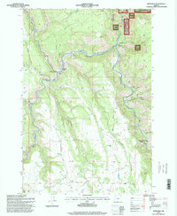
1995 Map of Rondowa
USGS Topo · Published 1998About this map
Rondowa serves as a focal point in this remote corner of northeastern Oregon, where the landscape is defined by the significant confluence of the Grande Ronde River and the Wallowa River. This 1995 revision, based on imagery from the previous year, highlights the winding canyons that dictate local transport and settlement patterns. The topography is exceptionally steep, with the surrounding timberlands and canyons under the jurisdiction of both the U.S. Forest Service and the Bureau of Land Management. Researchers will find a terrain carved by Duncan Canyon and Rysdam Canyon, showing how the rugged physical geography of the Wallowa-Whitman National Forest has historically constrained development to the narrow river benches and specific mountain junctions like Palmer Junction.
Find a feature on this map
1 named feature on this map. Tap any name to fly to it.
Don’t see what you’re looking for? This feature index may not catch every label — zoom into the map to look around manually.
Map Details
Editions of this 1995 Rondowa Map
This is the sole edition of this map. No revisions or reprints were ever made.
Other maps of this area

1955 · Grangeville
USGS Topo · 1:250,000

1959 · Grangeville
USGS Topo · 1:250,000

1964 · Partridge Creek
USGS Topo · 1:24,000

1964 · Howard Butte
USGS Topo · 1:24,000

1964 · Cricket Flat
USGS Topo · 1:24,000

1964 · Minam
USGS Topo · 1:24,000

1964 · Elgin
USGS Topo · 1:24,000

1964 · Rondowa
USGS Topo · 1:24,000

1967 · Fry Meadow
USGS Topo · 1:24,000
1967 · Deep Creek
USGS Topo · 1:24,000