
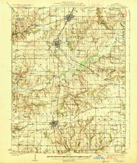
1926 Map of Roodhouse
USGS Topo · Published 1926About this map
Roodhouse, White Hall, and Carrollton anchor this central Illinois landscape during the mid-1920s, showing a region defined by its rail connectivity and dense network of rural schoolhouses. The Chicago and Alton railroad bisects the terrain, serving as a primary corridor through the rolling country between Apple Creek and Taylor Creek. The distribution of dozens of country schools, including curiously named sites like Swamp College School, Banding Dick School, and Pinhook School, illustrates the era's localized educational structure before district consolidation. Near Walkerville, the presence of Horseshoe Lake indicates the shift toward the lowlands near the river valley. Local life is further evidenced by several community landmarks such as Oakland Church, High Street Church, and Providence Church, which provided the social fabric for the surrounding farming townships of Wrights and Linder.
Find a feature on this map
74 named features on this map. Tap any name to fly to it.
Don’t see what you’re looking for? This feature index may not catch every label — zoom into the map to look around manually.
Map Details
Editions of this 1926 Roodhouse Map
2 editions found
Other maps of this area

1924 · Winchester
USGS Topo · 1:48,000

1924 · Roodhouse
USGS Topo · 1:62,500

1924 · Griggsville
USGS Topo · 1:62,500

1925 · Brighton
USGS Topo · 1:62,500

1926 · Griggsville
USGS Topo · 1:62,500

1926 · Winchester
USGS Topo · 1:62,500

1928 · Brighton
USGS Topo · 1:62,500

1930 · Pearl
USGS Topo · 1:62,500

1930 · Hardin
USGS Topo · 1:62,500

1930 · Jerseyville
USGS Topo · 1:62,500