
1941 Map of Rosario
USGS Topo · Published 1952About this map
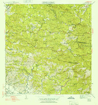
Agricultural haciendas define the landscape of this interior region of western Puerto Rico during the late 1930s and 1940s. The map illustrates a dense network of coffee and sugar estates, such as Hacienda Juanita, Hacienda Corcega, and Hacienda Esperanza, which served as the economic anchors for local communities before the island's mid-century industrial shift. Religious life is deeply integrated into the topography, with numerous small chapels and churches including Iglesia de San Jose and Capilla de Santa Ana.
Find a feature on this map
90 named features on this map. Tap any name to fly to it.
Don’t see what you’re looking for? This feature index may not catch every label — zoom into the map to look around manually.
Map Details
Editions of this 1941 Rosario Map
2 editions found
Other maps of this area

1935 · Puerto Real
USGS Topo · 1:25,000

1937 · San German
USGS Topo · 1:25,000

1937 · Sabana Grande
USGS Topo · 1:25,000

1937 · Puerto Real
USGS Topo · 1:25,000

1938 · Alto Sano
USGS Topo · 1:20,000

1938 · San Sebastian
USGS Topo · 1:20,000

1939 · Mayaguez
USGS Topo · 1:30,000

1941 · Rincon
USGS Topo · 1:30,000

1941 · San German
USGS Topo · 1:30,000

1941 · Puerto Real
USGS Topo · 1:30,000
Featured Places
- Sector Los Martinel, Las Marías
- Urb. Mansiones La Monserrate, Hormigueros
- Sector Coquí, Mayagüez
- Sector Punto Cubano, Hormigueros
- Sector Leclerc, Mayagüez