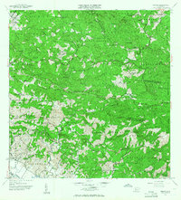
1955 Map of Rosario
USGS Topo · Published 1958About this map
Haciendas and coffee-growing culture define this mid-century landscape in the highlands of San Germán and Maricao. The settlement of Rosario serves as a central point for the region, where the Rio Rosario winds through complex topography. The map documents an agricultural economy still organized around estate names such as Hacienda Juanita, Hacienda Rosario, and Hacienda Salome.
Find a feature on this map
78 named features on this map. Tap any name to fly to it.
Don’t see what you’re looking for? This feature index may not catch every label — zoom into the map to look around manually.
Map Details
Editions of this 1955 Rosario Map
This is the sole edition of this map. No revisions or reprints were ever made.
Other maps of this area

1935 · Puerto Real
USGS Topo · 1:25,000

1937 · San German
USGS Topo · 1:25,000

1937 · Sabana Grande
USGS Topo · 1:25,000

1937 · Puerto Real
USGS Topo · 1:25,000

1938 · Alto Sano
USGS Topo · 1:20,000

1938 · San Sebastian
USGS Topo · 1:20,000

1939 · Mayaguez
USGS Topo · 1:30,000

1941 · Rincon
USGS Topo · 1:30,000

1941 · San German
USGS Topo · 1:30,000

1941 · Puerto Real
USGS Topo · 1:30,000
Featured Places
- Sector Los Martinel, Las Marías
- Urb. Mansiones La Monserrate, Hormigueros
- Sector Coquí, Mayagüez
- Sector Punto Cubano, Hormigueros
- Sector Leclerc, Mayagüez