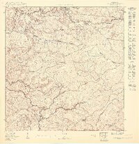
1950 Map of Rosario SE
USGS Topo · Published 1950About this map
Hacienda Palmares and Hacienda Córcega anchor this landscape within the Municipio de San Germán, reflecting the agricultural heritage of the region during the mid-20th century. The terrain is defined by the sharp ridges of Cuchillas Montoso and the protected lands of the Bosque Insular, which span across the municipal boundaries of Mayagüez and Maricao. These steep slopes overlook the valleys of the Río Rosario and Río Caín, where water management is evident through features like the Represa de Hoconuco and the Presada de San Germán.
Find a feature on this map
29 named features on this map. Tap any name to fly to it.
Don’t see what you’re looking for? This feature index may not catch every label — zoom into the map to look around manually.
Map Details
Editions of this 1950 Rosario SE Map
This is the sole edition of this map. No revisions or reprints were ever made.
Other maps of this area

1937 · San German
USGS Topo · 1:25,000

1937 · Sabana Grande
USGS Topo · 1:25,000

1941 · San German
USGS Topo · 1:30,000

1941 · Sabana Grande
USGS Topo · 1:30,000

1941 · Rosario
USGS Topo · 1:30,000

1942 · Rosario
USGS Topo · 1:30,000

1946 · Maricao
USGS Topo · 1:30,000
1947 · Maricao NO
USGS Topo · 1:10,000
1947 · Maricao SO
USGS Topo · 1:10,000
1949 · Sabana Grande NO
USGS Topo · 1:10,000