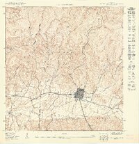
1949 Map of Sabana Grande NO
USGS Topo · Published 1949About this map
Sabana Grande serves as the central hub of this 1949 topographic study, situated in the fertile valley between the mountain ridges of Cain Alto and Machuchal. The town's layout is meticulously detailed, showing the street grid and individual structures alongside the Cementerio Municipal. Transportation and education dominate the local geography, with the American Railroad of Porto Rico tracking westward through the valley floor, passing the Escuela Hostos.
Find a feature on this map
30 named features on this map. Tap any name to fly to it.
Don’t see what you’re looking for? This feature index may not catch every label — zoom into the map to look around manually.
Map Details
Editions of this 1949 Sabana Grande NO Map
This is the sole edition of this map. No revisions or reprints were ever made.
Other maps of this area

1937 · San German
USGS Topo · 1:25,000

1937 · Sabana Grande
USGS Topo · 1:25,000

1941 · San German
USGS Topo · 1:30,000

1941 · Sabana Grande
USGS Topo · 1:30,000

1941 · Rosario
USGS Topo · 1:30,000

1942 · Rosario
USGS Topo · 1:30,000

1946 · Maricao
USGS Topo · 1:30,000
1947 · Maricao SO
USGS Topo · 1:10,000
1947 · Maricao SE
USGS Topo · 1:10,000
1949 · Sabana Grande NE
USGS Topo · 1:10,000
Featured Places
- Sabana Grande, Sabana Grande
- Villa Juanita, San Germán
- San Germán
- Guamá, San Germán
- Urb. San José, Sabana Grande