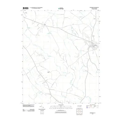
2010 Map of Roseboro
USGS Topo · Published 2010About this map
Roseboro sits at the eastern edge of this landscape, serving as a concentrated hub of commerce and community in Sampson County. The town is anchored by the Roseboro Post Office and bordered by Hollywood Cemetery, showing a settled pattern that contrasts with the expansive wetlands to the west. The terrain is defined by a dense network of water systems, including the South River and its numerous tributaries such as Mulatto Branch and Beaver Dam Creek.
Find a feature on this map
59 named features on this map. Tap any name to fly to it.
Don’t see what you’re looking for? This feature index may not catch every label — zoom into the map to look around manually.
Map Details
Editions of this 2010 Roseboro Map
This is the sole edition of this map. No revisions or reprints were ever made.
Other maps of this area

1909 · Coharie
USGS Topo · 1:62,500

1953 · Florence
USGS Topo · 1:250,000

1953 · Raleigh
USGS Topo · 1:250,000

1954 · Florence
USGS Topo · 1:250,000

1954 · Raleigh
USGS Topo · 1:250,000

1959 · Roseboro
USGS Topo · 1:62,500

1959 · Garland
USGS Topo · 1:62,500

1974 · Salemburg
USGS Topo · 1:24,000
1974 · Stedman
USGS Topo · 1:24,000

1982 · Elizabethtown
USGS Topo · 1:100,000