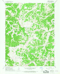
1965 Map of Rosebud
USGS Topo · Published 1967About this map
Rosebud and Drake anchor this mid-1960s landscape, which is defined by a dense network of clay mining and traditional rural community centers. Numerous Claypits are scattered throughout the hills, particularly around the northern reaches of Boeuf Creek, indicating a robust local extraction industry. The presence of several distinct congregations and burial grounds, such as Zoar Ch and its accompanying Zoar Cem, alongside St Johns Ch and New Salem Ch, points to a well-established social fabric tied to the land. Transportation is dominated by the Chicago Rock Island and Pacific railroad, which skirts the southern edge of the quadrangle. The topography is intricately carved by waterways like Big Hollow Branch and Langejammer Creek, creating the varied elevation typical of this Missouri region.
Find a feature on this map
27 named features on this map. Tap any name to fly to it.
Don’t see what you’re looking for? This feature index may not catch every label — zoom into the map to look around manually.
Map Details
Editions of this 1965 Rosebud Map
2 editions found
Other maps of this area

1890 · Hermann
USGS Topo · 1:125,000

1890 · Fulton
USGS Topo · 1:125,000

1903 · Sullivan
USGS Topo · 1:125,000

1934 · Bland
USGS Topo · 1:62,500

1935 · Gerald
USGS Topo · 1:48,000

1935 · Morrison
USGS Topo · 1:48,000

1936 · Hermann
USGS Topo · 1:48,000

1937 · Bland
USGS Topo · 1:62,500

1941 · Gerald
USGS Topo · 1:62,500

1942 · Morrison
USGS Topo · 1:62,500