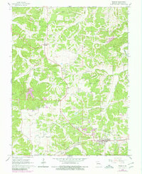
1965 Map of Rosebud
USGS Topo · Published 1980About this map
Clay extraction pits punctuate the hills and plateaus of Gasconade County, indicating a landscape defined by both agriculture and industry in the mid-1960s. Rosebud serves as a local hub along the Chicago Rock Island and Pacific railroad, which cuts through the southern portion of the map near Soap Creek. The settlement of Drake marks a significant crossroads further west. This area is notably rich in genealogical sites, featuring numerous rural burial grounds such as Georgetown Cem, Beemont Cem, and Matthews Cem, often situated near community churches like New Salem Ch and St Johns Ch. The drainage patterns of Boeuf Creek and its many tributaries, including Langejammer Creek and Schulte Creek, weave between these small settlements, reflecting the established rural infrastructure of the era before more modern development reached this part of Missouri.
Find a feature on this map
31 named features on this map. Tap any name to fly to it.
Don’t see what you’re looking for? This feature index may not catch every label — zoom into the map to look around manually.
Map Details
Editions of this 1965 Rosebud Map
2 editions found
Other maps of this area

1890 · Hermann
USGS Topo · 1:125,000

1890 · Fulton
USGS Topo · 1:125,000

1903 · Sullivan
USGS Topo · 1:125,000

1934 · Bland
USGS Topo · 1:62,500

1935 · Gerald
USGS Topo · 1:48,000

1935 · Morrison
USGS Topo · 1:48,000

1936 · Hermann
USGS Topo · 1:48,000

1937 · Bland
USGS Topo · 1:62,500

1941 · Gerald
USGS Topo · 1:62,500

1942 · Morrison
USGS Topo · 1:62,500