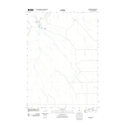
2012 Map of Rosebud
USGS Topo · Published 2012About this map
Rosebud Cr and its tributaries define the geography of this South Dakota landscape, where the waters of the W Br Rosebud Cr and E Br Rosebud Cr converge near the local center of activity. The map provides a detailed view of the infrastructure serving the Rosebud Indian Reservation, including the network of Bureau of Indian Affairs roads such as Bia 7 and Bia 1. For local historians, the placement of the Spotted Tail Cem and the Tribal Ranch offers insight into the community's land use and heritage. Prominent landmarks like Rosebud Butte overlook water features including Rosebud Lake and Indian Scout Lake, reflecting a terrain shaped by the winding paths of Wigwam Cr and Soldier Cr.
Find a feature on this map
16 named features on this map. Tap any name to fly to it.
Don’t see what you’re looking for? This feature index may not catch every label — zoom into the map to look around manually.
Map Details
Editions of this 2012 Rosebud Map
This is the sole edition of this map. No revisions or reprints were ever made.
Other maps of this area

1955 · Martin
USGS Topo · 1:250,000

1958 · Martin
USGS Topo · 1:250,000

1969 · Soldier Creek
USGS Topo · 1:24,000

1969 · Mission
USGS Topo · 1:24,000

1969 · Soldier Creek SE
USGS Topo · 1:24,000

1969 · Olsonville NW
USGS Topo · 1:24,000

1969 · Rosebud
USGS Topo · 1:24,000

1969 · St. Francis SW
USGS Topo · 1:24,000

1969 · Olsonville SW
USGS Topo · 1:24,000
1969 · St. Francis
USGS Topo · 1:24,000