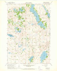
1967 Map of Rosendale
USGS Topo · Published 1968About this map
Glacial depressions and marshy basins define this 1960s landscape in Meeker County, where the transition from prairie to wetlands is meticulously documented. The settlement of Rosendale serves as a small focal point south of a significant cluster of lakes, including the elongated Long Lake and the circular Hope Lake. The map reveals a commitment to conservation during the mid-20th century, evidenced by the large footprints of the Acton State Wildlife Management Area and the Popular State Wildlife Management Area. Cultural landmarks such as Immanuel Ch and Arndahl Ch anchor the rural community, providing key points of reference for genealogists tracing family ties to the townships of Acton, Danielson, and Greenleaf. This survey also provides hydrographic depth soundings for major water bodies like Belle Lake, offering a rare look at lakebed topography before modern shifts in shoreline and water levels.
Find a feature on this map
22 named features on this map. Tap any name to fly to it.
Don’t see what you’re looking for? This feature index may not catch every label — zoom into the map to look around manually.
Map Details
Editions of this 1967 Rosendale Map
This is the sole edition of this map. No revisions or reprints were ever made.
Other maps of this area

1953 · New Ulm
USGS Topo · 1:250,000

1953 · Saint Cloud
USGS Topo · 1:250,000

1956 · Atwater
USGS Topo · 1:62,500

1957 · Saint Cloud
USGS Topo · 1:250,000

1957 · New Ulm
USGS Topo · 1:250,000

1957 · Olivia
USGS Topo · 1:62,500

1958 · New Ulm
USGS Topo · 1:250,000

1958 · Saint Cloud
USGS Topo · 1:250,000

1967 · New Ulm
USGS Topo · 1:250,000

1967 · Grove City
USGS Topo · 1:24,000