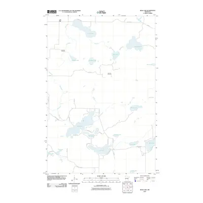
2010 Map of Ross Lake
USGS Topo · Published 2010About this map
Little Pine sits at the northern edge of this Minnesota lake country, where a dense network of water bodies and connecting brooks defines the geography of Crow Wing County. The landscape is structured by hydrological management, seen in features like the Birchdale Lake Dam on Birchdale Lake and the Little Pine Creek Dam located further east. This area serves as a primary drainage basin for Mud Brook, which meanders through several large basins including Lous Lake and Ross Lake.
Find a feature on this map
41 named features on this map. Tap any name to fly to it.
Don’t see what you’re looking for? This feature index may not catch every label — zoom into the map to look around manually.
Map Details
Editions of this 2010 Ross Lake Map
This is the sole edition of this map. No revisions or reprints were ever made.
Other maps of this area

1913 · Cuyuna
USGS Topo · 1:62,500

1914 · Aitkin
USGS Topo · 1:62,500

1915 · Aitkin
USGS Topo · 1:62,500

1915 · Cuyuna
USGS Topo · 1:62,500

1953 · Duluth
USGS Topo · 1:250,000

1958 · Duluth
USGS Topo · 1:250,000

1970 · Edna Lake
USGS Topo · 1:24,000
1970 · Roosevelt Lake
USGS Topo · 1:24,000

1970 · White Elk Lake
USGS Topo · 1:24,000
1973 · Emily
USGS Topo · 1:24,000