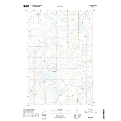
2019 Map of Ross Lake
USGS Topo · Published 2019About this map
Little Pine sits at the northern edge of this lake-strewn landscape in central Minnesota, where the boundary between Crow Wing and Aitkin Counties cuts through a dense network of water bodies and wetlands. The area is defined by its glacial hydrology, with Ross Lake and Stark Lake serving as central landmarks surrounded by smaller basins like Snodgrass Lake and Cranberry Lake. Drainage patterns are visible through the winding paths of Mud Brook and Ross Brook, which navigate the low-lying terrain between elevated ridges. The road network, including County Highway 1 and Cuyuna Trail, follows the natural contours of the land, providing access to the numerous lakefronts that dominate the local geography. This survey documents the modern layout of rural residential roads and public water access points that support the region's recreation-based economy.
Find a feature on this map
62 named features on this map. Tap any name to fly to it.
Don’t see what you’re looking for? This feature index may not catch every label — zoom into the map to look around manually.
Map Details
Editions of this 2019 Ross Lake Map
This is the sole edition of this map. No revisions or reprints were ever made.
Other maps of this area

1913 · Cuyuna
USGS Topo · 1:62,500

1914 · Aitkin
USGS Topo · 1:62,500

1915 · Aitkin
USGS Topo · 1:62,500

1915 · Cuyuna
USGS Topo · 1:62,500

1953 · Duluth
USGS Topo · 1:250,000

1958 · Duluth
USGS Topo · 1:250,000

1970 · Edna Lake
USGS Topo · 1:24,000
1970 · Roosevelt Lake
USGS Topo · 1:24,000

1970 · White Elk Lake
USGS Topo · 1:24,000
1973 · Emily
USGS Topo · 1:24,000