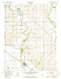
1952 Map of Rossville
USGS Topo · Published 1978About this map
The Union Pacific railroad corridor serves as the primary artery through this Kansas agricultural landscape, connecting the town of Rossville in the south to the smaller settlement of Delia in the north. The terrain is defined by the winding paths of Cross Creek and Soldier Creek, which have carved deep meanders across the townships of Washington, Rossville, and Grove. Evidence of early community structure is visible in the distribution of country schools and churches, such as Stone Sch, Victor Sch, and the Bohemian Ch.
Find a feature on this map
33 named features on this map. Tap any name to fly to it.
Don’t see what you’re looking for? This feature index may not catch every label — zoom into the map to look around manually.
Map Details
Editions of this 1952 Rossville Map
4 editions found
Other maps of this area

1889 · Wamego
USGS Topo · 1:125,000

1889 · Topeka
USGS Topo · 1:125,000

1894 · Topeka
USGS Topo · 1:125,000

1894 · Wamego
USGS Topo · 1:125,000

1950 · Kansas City
USGS Topo · 1:250,000

1952 · Rossville
USGS Topo · 1:24,000

1952 · Silver Lake
USGS Topo · 1:24,000

1952 · Grove
USGS Topo · 1:24,000
1952 · Willard
USGS Topo · 1:24,000

1953 · Maple Hill
USGS Topo · 1:24,000