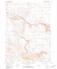
1963 Map of Roubadeau Pass
USGS Topo · Published 1983About this map
The Emigrant Trail cuts a historical path through this portion of Scotts Bluff County, tracing a route used by westward travelers across the Roubadeau Pass. This mid-century survey records the landscape just as the Department of the Interior was focusing on the development of the Missouri River Basin, evidenced by the intricate network of the Fort Laramie Canal, Mitchell Canal, and Gering Canal. These waterways navigate the elevation changes of the Wildcat Hills, providing essential irrigation to the high plains.
Find a feature on this map
42 named features on this map. Tap any name to fly to it.
Don’t see what you’re looking for? This feature index may not catch every label — zoom into the map to look around manually.
Map Details
Editions of this 1963 Roubadeau Pass Map
2 editions found
Other maps of this area

1898 · Scotts Bluff
USGS Topo · 1:125,000

1954 · Scottsbluff
USGS Topo · 1:250,000

1958 · Scottsbluff
USGS Topo · 1:250,000

1960 · Stegall
USGS Topo · 1:24,000

1960 · Murray Lake
USGS Topo · 1:24,000

1963 · Scottsbluff South
USGS Topo · 1:24,000

1963 · Mitchell
USGS Topo · 1:24,000

1963 · Scottsbluff North
USGS Topo · 1:24,000
1963 · Morrill
USGS Topo · 1:24,000

1963 · Roubadeau Pass
USGS Topo · 1:24,000