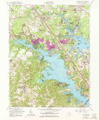
1956 Map of Round Bay
USGS Topo · Published 1972About this map
The Severn River and Magothy River define the intricate shoreline of Anne Arundel County in this mid-century survey, revised with 1970 aerial data. Purple overprint highlights the rapid suburban expansion of communities like Severna Park and Pasadena, while the Baltimore and Annapolis railroad line serves as a central corridor for growth. The landscape is dotted with long-standing local landmarks such as Silas Ch, Asbury Ch, and the extensive grounds of the Crownsville State Hospital. The transition from rural land to residential waterfront is visible across dozens of beach communities, including Mago Vista Beach and Arundel Beach. Significant local-history details are preserved here, from the Piney Grove Cem to industrial features like the Sand & Gravel Pit near Belvedere Heights. The map traces the evolving road network, from the historic Baltimore and Annapolis Road to the modern Severn River Bridge.
Find a feature on this map
114 named features on this map. Tap any name to fly to it.
Don’t see what you’re looking for? This feature index may not catch every label — zoom into the map to look around manually.
Map Details
Editions of this 1956 Round Bay Map
4 editions found
Other maps of this area

1892 · Owensville
USGS Topo · 1:62,500

1892 · Annapolis
USGS Topo · 1:62,500

1893 · North Point
USGS Topo · 1:62,500

1894 · Relay
USGS Topo · 1:62,500

1895 · Owensville
USGS Topo · 1:62,500

1898 · Choptank
USGS Topo · 1:125,000

1898 · Tolchester
USGS Topo · 1:125,000

1899 · Patuxent
USGS Topo · 1:125,000

1903 · Tolchester
USGS Topo · 1:125,000

1904 · North Point
USGS Topo · 1:62,500