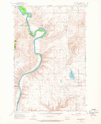
1965 Map of Round Butte
USGS Topo · Published 1967About this map
The Flathead River carves a deep, winding course through this mid-1960s landscape, marking the boundary between Lake and Sanders Counties. The topography is defined by the sharp contrast between the river's entrenched meanders and the elevated terrain of the Valley View Hills to the east. The settlement at Round Butte sits at the nexus of an extensive irrigation network, characterized by a complex system of waterways including the Pablo 71A Canal and the Pablo 73A Canal. This infrastructure, alongside the Horte Reservoir, underscores the vital role of water management in supporting the agricultural base of the region. A scattered distribution of structures and a dedicated Gravel Pit suggest a community built around resource extraction and land cultivation, while numerous ditches like the Pablo 73A5 Ditch branch out to serve the surrounding fields.
Find a feature on this map
13 named features on this map. Tap any name to fly to it.
Don’t see what you’re looking for? This feature index may not catch every label — zoom into the map to look around manually.
Map Details
Editions of this 1965 Round Butte Map
2 editions found
Other maps of this area

1920 · Flathead Lake
USGS Topo · 1:125,000

1956 · Wallace
USGS Topo · 1:250,000

1960 · Wallace
USGS Topo · 1:250,000

1964 · Buffalo Bridge
USGS Topo · 1:24,000

1964 · Melton Ranch
USGS Topo · 1:24,000

1964 · Polson
USGS Topo · 1:24,000

1964 · Lower Crow Reservoir
USGS Topo · 1:24,000

1965 · Sloan
USGS Topo · 1:24,000

1965 · Oliver Point
USGS Topo · 1:24,000
1965 · Irvine Hill
USGS Topo · 1:24,000