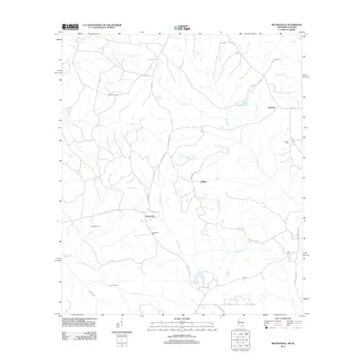
2012 Map of Rounsaville
USGS Topo · Published 2012About this map
Rounsaville and the surrounding pine-heavy landscapes of Greene County are captured here in the early twenty-first century, showing a network of rural routes and family-named landmarks. The terrain is defined by the winding course of Okuakee Cr and the dense wetlands of Martins Swamp, illustrating the local reliance on creek-fed drainages like Sand Cr and Lewis Cr. Settlement patterns appear dispersed, centered around small communities such as Walley and Burbank, with local history preserved in the Rounsaville Cem, Burbank Cem, and Turner Cem. The presence of Stalworth Camp and several named logging roads like Log Rd and Mizell Rd suggest the ongoing importance of the timber industry and seasonal camps in this part of Mississippi. Residential clusters are most visible along Bernard Loop and the various county highways that link these isolated outposts.
Find a feature on this map
51 named features on this map. Tap any name to fly to it.
Don’t see what you’re looking for? This feature index may not catch every label — zoom into the map to look around manually.
Map Details
Editions of this 2012 Rounsaville Map
This is the sole edition of this map. No revisions or reprints were ever made.
Other maps of this area

1942 · Deer Park
USGS Topo · 1:62,500

1943 · Deer Park
USGS Topo · 1:62,500

1953 · Hattiesburg
USGS Topo · 1:250,000

1958 · Hattiesburg
USGS Topo · 1:250,000

1964 · Clark
USGS Topo · 1:24,000

1972 · Leakesville
USGS Topo · 1:24,000
1972 · Vernal
USGS Topo · 1:24,000

1974 · Fruitdale
USGS Topo · 1:24,000

1974 · Vinegar Bend
USGS Topo · 1:24,000
1982 · Citronelle West
USGS Topo · 1:24,000