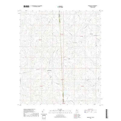
2018 Map of Rounsaville
USGS Topo · Published 2018About this map
Rounsaville and the surrounding rural pocket of Greene County sit along the undulating border between Mississippi and Alabama. This landscape is defined by its complex drainage network, where waters flow through Okwakee Cr and Robertson Cr into the wetlands of Martins Swamp. The settlement patterns here are modest, centered around small communities like Walley and Burbank, which are connected by a web of local routes such as Rounsaville Rd and Double Branch Rd. Genealogy is written into the terrain through family-named landmarks and resting places, including Rounsaville Cem and Turner Cem. The map reveals a place where the local economy and daily life follow the contours of the creeks and branches, from the secluded waters of James Anthony Lake to the aptly named Nobodies Cr.
Find a feature on this map
60 named features on this map. Tap any name to fly to it.
Don’t see what you’re looking for? This feature index may not catch every label — zoom into the map to look around manually.
Map Details
Editions of this 2018 Rounsaville Map
This is the sole edition of this map. No revisions or reprints were ever made.
Other maps of this area

1942 · Deer Park
USGS Topo · 1:62,500

1943 · Deer Park
USGS Topo · 1:62,500

1953 · Hattiesburg
USGS Topo · 1:250,000

1958 · Hattiesburg
USGS Topo · 1:250,000

1964 · Clark
USGS Topo · 1:24,000

1972 · Leakesville
USGS Topo · 1:24,000
1972 · Vernal
USGS Topo · 1:24,000

1974 · Fruitdale
USGS Topo · 1:24,000

1974 · Vinegar Bend
USGS Topo · 1:24,000
1982 · Citronelle West
USGS Topo · 1:24,000