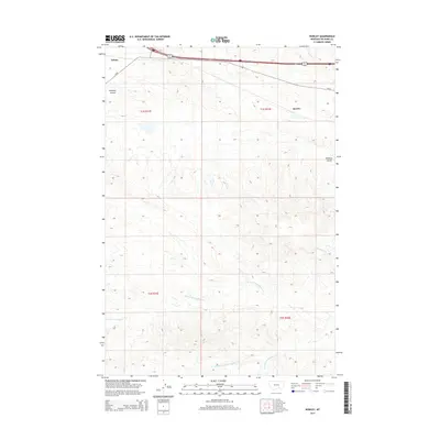
2014 Map of Rowley
USGS Topo · Published 2014About this map
Rowley and Toluca serve as the primary human touchpoints in this Big Horn County landscape, where the high plains are carved by a complex network of coulees and creek forks. The northern section of the map is defined by the east-west corridor of Us-87, which connects these small settlements across a high plateau. Below this transportation artery, the terrain descends into a series of drainages, most notably the three branches of Two Leggins Creek—the N Fork Two Leggins Cr, Middle Fork Two Leggins Cr, and S Fork Two Leggins Cr. This drainage system, along with Williams Coulee and Cottonwood Cr, illustrates the intricate erosion patterns typical of the region. The map preserves the exact alignment of section lines and township boundaries, such as t1s r32e, providing a clear framework for those studying land ownership and rural development in this part of Montana.
Find a feature on this map
13 named features on this map. Tap any name to fly to it.
Don’t see what you’re looking for? This feature index may not catch every label — zoom into the map to look around manually.
Map Details
Editions of this 2014 Rowley Map
This is the sole edition of this map. No revisions or reprints were ever made.
Other maps of this area

1894 · Fort Custer
USGS Topo · 1:125,000

1954 · Hardin
USGS Topo · 1:250,000

1957 · Hardin
USGS Topo · 1:250,000

1958 · Hardin
USGS Topo · 1:250,000

1960 · Chimney Creek
USGS Topo · 1:24,000

1960 · Walker Hill
USGS Topo · 1:24,000

1960 · Hardin SW
USGS Topo · 1:24,000
1969 · Rowley NW
USGS Topo · 1:24,000
1969 · Rowley
USGS Topo · 1:24,000
1969 · Bentonite Flats
USGS Topo · 1:24,000