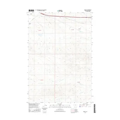
2017 Map of Rowley
USGS Topo · Published 2017About this map
Rowley and Toluca serve as the primary markers of human settlement in this high plains landscape of Big Horn County. The modern transport corridor of Interstate 90 and the shared route of Highway 87 212 cut across the northern portion of the quadrangle, running parallel to the winding path of Old US Hwy 87. This overlay of contemporary and historic roadbeds suggests the long-term importance of this route across the Montana territory.
Find a feature on this map
15 named features on this map. Tap any name to fly to it.
Don’t see what you’re looking for? This feature index may not catch every label — zoom into the map to look around manually.
Map Details
Editions of this 2017 Rowley Map
This is the sole edition of this map. No revisions or reprints were ever made.
Other maps of this area

1894 · Fort Custer
USGS Topo · 1:125,000

1954 · Hardin
USGS Topo · 1:250,000

1957 · Hardin
USGS Topo · 1:250,000

1958 · Hardin
USGS Topo · 1:250,000

1960 · Chimney Creek
USGS Topo · 1:24,000

1960 · Walker Hill
USGS Topo · 1:24,000

1960 · Hardin SW
USGS Topo · 1:24,000
1969 · Rowley NW
USGS Topo · 1:24,000
1969 · Rowley
USGS Topo · 1:24,000
1969 · Bentonite Flats
USGS Topo · 1:24,000