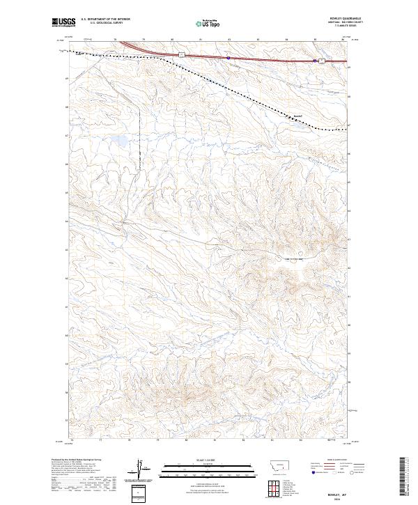
2024 Map of Rowley
USGS Topo · Published 2024About this map
Rowley and Toluca represent the small-scale settlement patterns of Big Horn County, Montana, situated in a landscape defined by an intricate network of drainage systems. The northern portion of the map is dominated by the path of Old US Hwy 87, which follows the natural contours of the land alongside Peritsu Creek. The terrain is deeply carved by watercourses, most notably the three branches of the Two Leggins Creek system: North Fork Two Leggins Creek, Middle Fork Two Leggins Creek, and South Fork Two Leggins Creek. These forks, along with Williams Coulee and Cottonwood Creek, illustrate the complex erosion patterns typical of this Montana region. This contemporary survey by the U.S. Geological Survey provides a detailed topographic record of the area's rural transportation and hydrography as they exist in the early twenty-first century.
Find a feature on this map
14 named features on this map. Tap any name to fly to it.
Don’t see what you’re looking for? This feature index may not catch every label — zoom into the map to look around manually.
Map Details
Editions of this 2024 Rowley Map
This is the sole edition of this map. No revisions or reprints were ever made.
Other maps of this area

1894 · Fort Custer
USGS Topo · 1:125,000

1954 · Hardin
USGS Topo · 1:250,000

1957 · Hardin
USGS Topo · 1:250,000

1958 · Hardin
USGS Topo · 1:250,000

1960 · Chimney Creek
USGS Topo · 1:24,000

1960 · Walker Hill
USGS Topo · 1:24,000

1960 · Hardin SW
USGS Topo · 1:24,000
1969 · Rowley NW
USGS Topo · 1:24,000
1969 · Rowley
USGS Topo · 1:24,000
1969 · Bentonite Flats
USGS Topo · 1:24,000