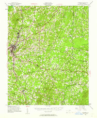
1943 Map of Roxboro
USGS Topo · Published 1962About this map
Roxboro serves as the industrial and civic heart of this Person County landscape during the early 1940s, with the Norfolk and Western railroad corridor facilitating commerce through Longhurst and Helena. To the southeast, the established presence of the Camp Butner Military Reservation reflects the wartime mobilization of the era, occupying a significant portion of the terrain near Moriah. The geography is defined by the headwaters of the Flat River, Tar River, and Aarons Creek, which carve through the Piedmont hills anchored by Hagers Mountain. Rural life is meticulously documented through a network of family-named landmarks and crossroads like Gentry Store and Dixon Store. Local education and faith are central to the settlement pattern, evidenced by numerous rural institutions such as Cedar Grove School No 1, Siloam Sch, and Vermont Hill Ch, providing a detailed look at the social fabric of North Carolina before mid-century modernization.
Find a feature on this map
58 named features on this map. Tap any name to fly to it.
Don’t see what you’re looking for? This feature index may not catch every label — zoom into the map to look around manually.
Map Details
Editions of this 1943 Roxboro Map
2 editions found
Other maps of this area

1941 · Clarksville
USGS Topo · 1:48,000

1943 · Clarksville
USGS Topo · 1:62,500

1943 · Roxboro
USGS Topo · 1:62,500

1943 · Creedmoor
USGS Topo · 1:62,500

1944 · Creedmoor
USGS Topo · 1:62,500

1951 · Durham North
USGS Topo · 1:62,500

1952 · Milton
USGS Topo · 1:62,500

1953 · Oxford
USGS Topo · 1:62,500

1953 · South Boston
USGS Topo · 1:62,500

1953 · Greensboro
USGS Topo · 1:250,000