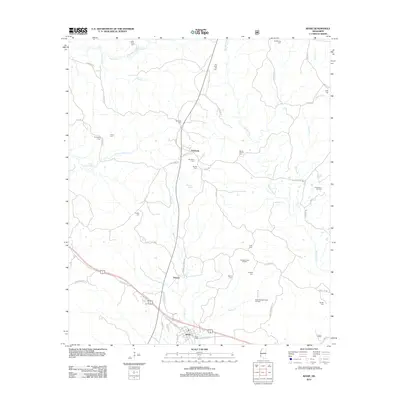
2012 Map of Roxie
USGS Topo · Published 2012About this map
The town of Roxie sits at a significant junction in western Mississippi, where the landscape transitions into a complex web of petroleum extraction and rural cemeteries. This 2012 survey illustrates a region defined by its energy economy, featuring the Oldenburg Oil Field, Morgan Creek Oil Field, and South Morgan Creek Oil Field. These industrial sites are interspersed with deep-rooted community landmarks, particularly a high density of burial grounds such as Old Rose Hill Cem, Mount Carmel Cem, and Mundy Cem. The drainage of the area is primarily handled by Morgan Fork and S Fork Coles Cr, which carve through the terrain near the small settlements of Hamburg and Orange. For genealogists and local historians, the map provides precise locations for family-named roads like Stampley Rd and McNair Rd, alongside notable water features such as Wildwood Spring.
Find a feature on this map
62 named features on this map. Tap any name to fly to it.
Don’t see what you’re looking for? This feature index may not catch every label — zoom into the map to look around manually.
Map Details
Editions of this 2012 Roxie Map
This is the sole edition of this map. No revisions or reprints were ever made.
Other maps of this area

1953 · Natchez
USGS Topo · 1:250,000

1956 · Natchez
USGS Topo · 1:250,000

1959 · Natchez
USGS Topo · 1:250,000

1961 · Crosby
USGS Topo · 1:62,500

1962 · Fayette
USGS Topo · 1:62,500

1962 · Bude
USGS Topo · 1:62,500

1963 · Union Church
USGS Topo · 1:62,500
1984 · Natchez
USGS Topo · 1:100,000

1984 · Brookhaven
USGS Topo · 1:100,000

1984 · McComb
USGS Topo · 1:100,000