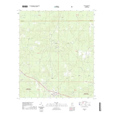
2021 Map of Roxie
USGS Topo · Published 2021About this map
Roxie serves as the focal point of this region in southwestern Mississippi, where the grid of streets like Tennessee St and Alabama St marks a small community surrounded by the Homochitto National Forest. The landscape is defined by the winding drainages of Morgan Fork, Wells Cr, and S Fork Coles Cr, which cut through a terrain dotted with ancestral burial grounds. Genealogists will find a dense distribution of sites such as Saint Paul Cem, Old Rose Hill Cem, and Prophet Cem. Moving north toward Hamburg, the map reveals a network of local roads including Hamburg Rd and Cutoff Rd NW. The presence of both Old Beech Grove Cem and Beech Grove Cem suggests a shifting community center over time, while landmarks like Wildwood Spring and the small settlement of Orange provide additional points of interest within the forest boundaries.
Find a feature on this map
71 named features on this map. Tap any name to fly to it.
Don’t see what you’re looking for? This feature index may not catch every label — zoom into the map to look around manually.
Map Details
Editions of this 2021 Roxie Map
This is the sole edition of this map. No revisions or reprints were ever made.
Other maps of this area

1953 · Natchez
USGS Topo · 1:250,000

1956 · Natchez
USGS Topo · 1:250,000

1959 · Natchez
USGS Topo · 1:250,000

1961 · Crosby
USGS Topo · 1:62,500

1962 · Fayette
USGS Topo · 1:62,500

1962 · Bude
USGS Topo · 1:62,500

1963 · Union Church
USGS Topo · 1:62,500
1984 · Natchez
USGS Topo · 1:100,000

1984 · Brookhaven
USGS Topo · 1:100,000

1984 · McComb
USGS Topo · 1:100,000