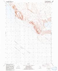
1991 Map of Rozel Point
USGS Topo · Published 1991About this map
Gunnison Bay and Rozel Bay meet at the distinctive southern tip of the Rozel Hills in this 1991 revision of Box Elder County's shoreline. The map documents the stark interface between the Great Salt Lake and the shifting terrestrial landscape of Mud flats and volcanic outcrops. An Airway Beacon stands atop the highest ridges of the hills, marking a critical navigation point for pilots crossing the desert basins. Farther east, the transition into Rozel Flat is marked by a Gravel Pit and a network of 4wd tracks, illustrating the localized industrial and recreational use of this remote peninsula. The topographic contours reveal the varied elevations of the lake bed, which was recorded at an elevation of 4200 feet, providing a precise record of the water line during the late 20th century.
Find a feature on this map
13 named features on this map. Tap any name to fly to it.
Don’t see what you’re looking for? This feature index may not catch every label — zoom into the map to look around manually.
Map Details
Editions of this 1991 Rozel Point Map
This is the sole edition of this map. No revisions or reprints were ever made.
Other maps of this area

1954 · Brigham City
USGS Topo · 1:250,000

1958 · Brigham City
USGS Topo · 1:250,000

1962 · Brigham City
USGS Topo · 1:250,000

1967 · Golden Spike Monument
USGS Topo · 1:24,000

1968 · Messix Peak
USGS Topo · 1:24,000

1968 · Rozel
USGS Topo · 1:24,000

1968 · Coyote Point
USGS Topo · 1:24,000

1968 · Indian Cove
USGS Topo · 1:24,000

1968 · Rozel Point
USGS Topo · 1:24,000

1969 · Rozel Point SW
USGS Topo · 1:24,000