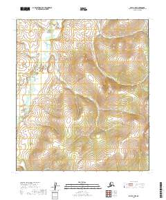
2019 Map of Ruby A-1 NW
USGS Topo · Published 2019About this map
Telsitna River meanders through the western portion of this terrain, defining the local drainage pattern within the Yukon-Koyukuk region. The landscape is characterized by significant topographical relief, with elevations rising steeply from the river valley toward prominent ridge lines in the east. Surveyed by the U.S. Geological Survey and the Bureau of Land Management, the map illustrates the Public Land Survey System grid across multiple townships including t14s r27e, t15s r28e, and t16s r27e. This 2019 data represents a contemporary view of a remote Alaskan interior, showing a complete absence of named settlements, roads, or man-made structures, emphasizing the wilderness character of the Telsitna basin.
Find a feature on this map
7 named features on this map. Tap any name to fly to it.
Don’t see what you’re looking for? This feature index may not catch every label — zoom into the map to look around manually.
Map Details
Editions of this 2019 Ruby A-1 NW Map
This is the sole edition of this map. No revisions or reprints were ever made.
Other maps of this area

1951 · Ruby
USGS Topo · 1:250,000

1952 · Ruby A-2
USGS Topo · 1:63,360

1952 · Ruby B-1
USGS Topo · 1:63,360

1952 · Ruby B-2
USGS Topo · 1:63,360

1952 · Ruby A-1
USGS Topo · 1:63,360

1952 · Ruby
USGS Topo · 1:250,000

1964 · Ruby
USGS Topo · 1:250,000
2019 · Ruby A-1 NE
USGS Topo · 1:25,000
2019 · Ruby B-1 SW
USGS Topo · 1:25,000
2019 · Ruby A-2 SE
USGS Topo · 1:25,000