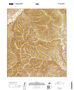
2019 Map of Ruby A-3 NW
USGS Topo · Published 2019About this map
The Lost River winds through the northern portion of this Yukon-Koyukuk region, its drainage system carving through an undulating interior landscape. This 2019 survey documents the extensive Public Land Survey System (PLSS) grid, defining the intersections of t14s r22e, t14s r23e, and t15s r22e among others. The terrain is characterized by detailed contouring that reveals a complex network of ridges and seasonal drainages typical of the Alaska interior. While the map is devoid of named settlements or man-made structures, it serves as a precise record of the natural hydrology and land divisions within the Ruby A-3 NW quadrangle.
Find a feature on this map
7 named features on this map. Tap any name to fly to it.
Don’t see what you’re looking for? This feature index may not catch every label — zoom into the map to look around manually.
Map Details
Editions of this 2019 Ruby A-3 NW Map
This is the sole edition of this map. No revisions or reprints were ever made.
Other maps of this area

1951 · Ruby
USGS Topo · 1:250,000

1952 · Ruby A-3
USGS Topo · 1:63,360

1952 · Ruby A-4
USGS Topo · 1:63,360

1952 · Ruby B-4
USGS Topo · 1:63,360

1952 · Ruby B-3
USGS Topo · 1:63,360

1952 · Ruby
USGS Topo · 1:250,000
1953 · Ruby B-3
USGS Topo · 1:63,360

1964 · Ruby
USGS Topo · 1:250,000
2019 · Ruby B-3 SE
USGS Topo · 1:25,000
2019 · Ruby B-3 SW
USGS Topo · 1:25,000