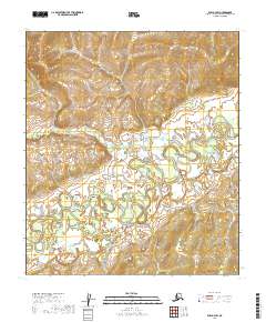
2019 Map of Ruby A-3 SW
USGS Topo · Published 2019About this map
The Nowitna River meanders across this interior Alaskan landscape, defining the low-lying terrain within the Ruby A-3 SW quadrangle. The river’s complex oxbows and floodplains dominate the southern and central portions of the sheet, providing a sharp contrast to the more elevated, rhythmic contouring found in the northern sections. This 2019 survey documents the wild hydrography of the region, including the confluence where Our Cr feeds into the larger waterway.
Find a feature on this map
7 named features on this map. Tap any name to fly to it.
Don’t see what you’re looking for? This feature index may not catch every label — zoom into the map to look around manually.
Map Details
Editions of this 2019 Ruby A-3 SW Map
This is the sole edition of this map. No revisions or reprints were ever made.
Other maps of this area

1950 · Medfra
USGS Topo · 1:250,000

1951 · Ruby
USGS Topo · 1:250,000

1952 · Ruby A-3
USGS Topo · 1:63,360

1952 · Ruby A-4
USGS Topo · 1:63,360

1952 · Ruby
USGS Topo · 1:250,000
1954 · Medfra D-3
USGS Topo · 1:63,360
1954 · Medfra D-4
USGS Topo · 1:63,360

1959 · Medfra
USGS Topo · 1:250,000

1964 · Ruby
USGS Topo · 1:250,000
2019 · Medfra D-3 NW
USGS Topo · 1:25,000