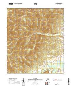
2019 Map of Ruby A-4 SE
USGS Topo · Published 2019About this map
The Nowitna River meanders through the southeastern corner of this Alaskan interior landscape, its braided channels and oxbow bends providing the primary geographic signature for this unpopulated wilderness area. This modern survey, produced from SPOT imagery and the National Elevation Dataset, illustrates the complex topography of the Ruby A-4 SE region without a single road, structure, or named landmark outside of the river basin. The map is primarily an exercise in elevation and public land surveying, clearly delineating the boundaries of townships t16s r21e, t16s r22e, t17s r21e, and t17s r22e across the vast, high-altitude terrain.
Find a feature on this map
5 named features on this map. Tap any name to fly to it.
Don’t see what you’re looking for? This feature index may not catch every label — zoom into the map to look around manually.
Map Details
Editions of this 2019 Ruby A-4 SE Map
This is the sole edition of this map. No revisions or reprints were ever made.
Other maps of this area

1950 · Medfra
USGS Topo · 1:250,000

1951 · Ruby
USGS Topo · 1:250,000

1952 · Ruby A-3
USGS Topo · 1:63,360

1952 · Ruby A-4
USGS Topo · 1:63,360

1952 · Ruby
USGS Topo · 1:250,000
1954 · Medfra D-3
USGS Topo · 1:63,360
1954 · Medfra D-4
USGS Topo · 1:63,360

1959 · Medfra
USGS Topo · 1:250,000

1964 · Ruby
USGS Topo · 1:250,000
2019 · Medfra D-3 NW
USGS Topo · 1:25,000