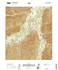
2019 Map of Ruby A-5 NE
USGS Topo · Published 2019About this map
The Sulatna River meanders through this interior Alaska landscape, creating a complex network of wetlands and oxbows within the Ruby A-5 NE quadrangle. This 2019 survey captures the river's winding course as it receives numerous tributaries, including Antoski Cr in the northwest and Wood Cr further south. The drainage patterns here are well-defined by several smaller waterways such as Musters Cr and Muty Cr, which feed into the main channel from the surrounding hills.
Find a feature on this map
14 named features on this map. Tap any name to fly to it.
Don’t see what you’re looking for? This feature index may not catch every label — zoom into the map to look around manually.
Map Details
Editions of this 2019 Ruby A-5 NE Map
This is the sole edition of this map. No revisions or reprints were ever made.
Other maps of this area

1951 · Ruby
USGS Topo · 1:250,000

1952 · Ruby A-4
USGS Topo · 1:63,360

1952 · Ruby B-4
USGS Topo · 1:63,360

1952 · Ruby B-5
USGS Topo · 1:63,360

1952 · Ruby A-5
USGS Topo · 1:63,360

1952 · Ruby
USGS Topo · 1:250,000

1964 · Ruby
USGS Topo · 1:250,000
2019 · Ruby A-4 NW
USGS Topo · 1:25,000
2019 · Ruby A-5 SW
USGS Topo · 1:25,000
2019 · Ruby A-4 SW
USGS Topo · 1:25,000