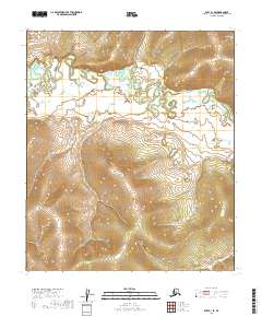
2019 Map of Ruby B-1 SE
USGS Topo · Published 2019About this map
Titna River meanders across the northern half of this Interior Alaska landscape, creating a complex network of oxbow lakes and wetlands within the Ruby B-1 SE quadrangle. The river’s winding course dominates the central basin, where the water cuts through varied elevations before the terrain rises sharply toward the southern boundary. In the southeastern corner, Baker Cr drains a significant drainage area, highlighting the hydrological pattern of this remote subarctic region. The map primarily documents the intricate topography and township boundaries of the Yukon-Koyukuk Census Area, illustrating the transition from river bottomlands to the surrounding uplands without the presence of established roads or permanent settlements.
Find a feature on this map
11 named features on this map. Tap any name to fly to it.
Don’t see what you’re looking for? This feature index may not catch every label — zoom into the map to look around manually.
Map Details
Editions of this 2019 Ruby B-1 SE Map
This is the sole edition of this map. No revisions or reprints were ever made.
Other maps of this area

1948 · Kantishna River
USGS Topo · 1:250,000

1951 · Kantishna River
USGS Topo · 1:250,000

1951 · Ruby
USGS Topo · 1:250,000

1952 · Ruby B-1
USGS Topo · 1:63,360

1952 · Ruby A-1
USGS Topo · 1:63,360

1952 · Kantishna River
USGS Topo · 1:250,000

1952 · Kantishna River B-6
USGS Topo · 1:63,360

1952 · Kantishna River A-6
USGS Topo · 1:63,360

1952 · Ruby
USGS Topo · 1:250,000
1953 · Kantishna River A-6
USGS Topo · 1:63,360