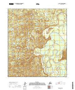
2019 Map of Ruby C-4 NE
USGS Topo · Published 2019About this map
The Nowitna River meanders in intricate loops across this interior Alaskan landscape, defining the character of the terrain within the Ruby C-4 NE region. The map illustrates a complex network of oxbow lakes, sloughs, and wetlands that have formed as the river shifts its course through the broad, low-lying valley. This hydrologic pattern, typical of the Yukon-Koyukuk Census Area, reveals the natural dynamics of a wild river system untouched by permanent settlements or industrial development at this scale. Detailed contour lines and hydrographic data from the Nowitna River basin provide an exact record of the floodplain's geometry as it existed during the 2010s.
Find a feature on this map
7 named features on this map. Tap any name to fly to it.
Don’t see what you’re looking for? This feature index may not catch every label — zoom into the map to look around manually.
Map Details
Editions of this 2019 Ruby C-4 NE Map
This is the sole edition of this map. No revisions or reprints were ever made.
Other maps of this area

1951 · Ruby
USGS Topo · 1:250,000

1952 · Ruby D-4
USGS Topo · 1:63,360

1952 · Ruby C-3
USGS Topo · 1:63,360

1952 · Ruby D-3
USGS Topo · 1:63,360

1952 · Ruby C-4
USGS Topo · 1:63,360

1952 · Ruby
USGS Topo · 1:250,000
1953 · Ruby D-4
USGS Topo · 1:63,360

1964 · Ruby
USGS Topo · 1:250,000
2019 · Ruby C-4 NW
USGS Topo · 1:25,000
2019 · Ruby D-4 SE
USGS Topo · 1:25,000