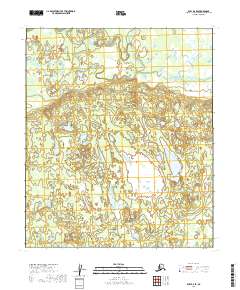
2019 Map of Ruby D-4 SE
USGS Topo · Published 2019About this map
Grass Lake lies at the heart of this Yukon-Koyukuk landscape, where complex wetland patterns and small ponds dominate the central terrain. To the north, the winding course of Twin Slough indicates the presence of a dynamic river system, while Deer Cr cuts through the western sections. The map reveals the intricate drainage and muskeg typical of this Alaskan region, showcasing a topography defined more by water and marsh than by human development. Surveyed in the early twenty-first century, the sheet documents the natural state of these watersheds across several township boundaries, including t7s r21e and t8s r21e, providing a baseline for environmental study and navigational reference in an area devoid of modern road networks.
Find a feature on this map
8 named features on this map. Tap any name to fly to it.
Don’t see what you’re looking for? This feature index may not catch every label — zoom into the map to look around manually.
Map Details
Editions of this 2019 Ruby D-4 SE Map
This is the sole edition of this map. No revisions or reprints were ever made.
Other maps of this area

1951 · Ruby
USGS Topo · 1:250,000

1952 · Ruby D-4
USGS Topo · 1:63,360

1952 · Ruby C-3
USGS Topo · 1:63,360

1952 · Ruby D-3
USGS Topo · 1:63,360

1952 · Ruby C-4
USGS Topo · 1:63,360

1952 · Ruby
USGS Topo · 1:250,000
1953 · Ruby D-4
USGS Topo · 1:63,360

1964 · Ruby
USGS Topo · 1:250,000
2019 · Ruby C-4 NW
USGS Topo · 1:25,000
2019 · Ruby D-4 SW
USGS Topo · 1:25,000