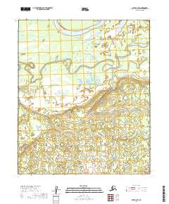
2019 Map of Ruby D-4 SW
USGS Topo · Published 2019About this map
Junetaket Slough defines the northern reaches of this interior Alaskan landscape, marking a complex drainage pattern typical of the Yukon-Koyukuk region. This 2019 survey captures a sparsely settled wilderness dominated by intricate wetlands and seasonal waterways. The central and western portions of the quadrangle are primarily drained by the meandering course of Deer Creek, while the southeastern corner is anchored by the isolated waters of June Lake. The map reveals the underlying Public Land Survey System structure, covering portions of t7s r19e, t7s r20e, t8s r19e, and t8s r20e. This terrain reflects a largely untouched natural environment where topographical changes are subtle and water remains the primary shaping force.
Find a feature on this map
7 named features on this map. Tap any name to fly to it.
Don’t see what you’re looking for? This feature index may not catch every label — zoom into the map to look around manually.
Map Details
Editions of this 2019 Ruby D-4 SW Map
This is the sole edition of this map. No revisions or reprints were ever made.
Other maps of this area

1951 · Ruby
USGS Topo · 1:250,000

1952 · Ruby D-4
USGS Topo · 1:63,360

1952 · Ruby D-5
USGS Topo · 1:63,360

1952 · Ruby C-5
USGS Topo · 1:63,360

1952 · Ruby C-4
USGS Topo · 1:63,360

1952 · Ruby
USGS Topo · 1:250,000
1953 · Ruby D-4
USGS Topo · 1:63,360

1964 · Ruby
USGS Topo · 1:250,000
2019 · Ruby C-4 NW
USGS Topo · 1:25,000
2019 · Ruby D-4 SE
USGS Topo · 1:25,000