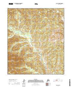
2019 Map of Ruby C-5 NE
USGS Topo · Published 2019About this map
Cecil Dome commands the southwestern corner of this interior Alaskan landscape, serving as the primary topographic landmark in a region defined by its complex drainage systems. The survey detail illustrates how Big Cr and Little Boulder Cr carve through the terrain, indicating the natural movement of water across the central Yukon-Koyukuk Census Area. This 2019 data release from the U.S. Geological Survey utilizes imagery from 2010 to document a wilderness area largely devoid of permanent human infrastructure, offering a clear view of the natural contours and the township and range divisions of the Public Land Survey System. The map provides an essential baseline for understanding the hydrologic patterns and elevation shifts in this remote portion of the Ruby C-5 NE quadrangle.
Find a feature on this map
9 named features on this map. Tap any name to fly to it.
Don’t see what you’re looking for? This feature index may not catch every label — zoom into the map to look around manually.
Map Details
Editions of this 2019 Ruby C-5 NE Map
This is the sole edition of this map. No revisions or reprints were ever made.
Other maps of this area

1951 · Ruby
USGS Topo · 1:250,000

1952 · Ruby D-4
USGS Topo · 1:63,360

1952 · Ruby D-5
USGS Topo · 1:63,360

1952 · Ruby C-5
USGS Topo · 1:63,360

1952 · Ruby C-4
USGS Topo · 1:63,360

1952 · Ruby
USGS Topo · 1:250,000
1953 · Ruby D-4
USGS Topo · 1:63,360

1964 · Ruby
USGS Topo · 1:250,000
2019 · Ruby C-4 NW
USGS Topo · 1:25,000
2019 · Ruby D-4 SW
USGS Topo · 1:25,000