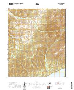
2019 Map of Ruby D-5 NE
USGS Topo · Published 2019About this map
Yukon River waters define the southeastern corner of this landscape, where the massive river system meets the dramatic elevation of the White Cliffs. The terrain rises sharply from the riverbanks into the Kokrines Hills, a series of ridges and summits that dominate the central and northern portions of the quadrangle. This 2019 survey documents the natural drainage patterns of the interior, centered on the winding courses of Shovel Cr and McAntee Cr. The map illustrates the transition from the low-lying river corridor to the higher, rolling elevations of the northern hills. Without roads or settlements, the sheet serves as a primary record of the topographic character and hydrological network within the Yukon-Koyukuk region.
Find a feature on this map
9 named features on this map. Tap any name to fly to it.
Don’t see what you’re looking for? This feature index may not catch every label — zoom into the map to look around manually.
Map Details
Editions of this 2019 Ruby D-5 NE Map
This is the sole edition of this map. No revisions or reprints were ever made.
Other maps of this area

1951 · Ruby
USGS Topo · 1:250,000

1951 · Melozitna
USGS Topo · 1:250,000

1952 · Ruby D-4
USGS Topo · 1:63,360

1952 · Ruby D-5
USGS Topo · 1:63,360

1952 · Ruby
USGS Topo · 1:250,000

1953 · Melozitna A-4
USGS Topo · 1:63,360
1953 · Ruby D-4
USGS Topo · 1:63,360
1954 · Melozitna A-5
USGS Topo · 1:63,360

1956 · Melozitna
USGS Topo · 1:250,000

1964 · Ruby
USGS Topo · 1:250,000