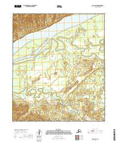
2019 Map of Ruby D-5 SE
USGS Topo · Published 2019About this map
The Yukon River dominates this portion of the Alaska interior, carving a massive channel that separates the upland terrain of the north from the low-lying wetlands and sloughs to the south. This 2019 survey documents the complex hydrology of the river's flood plain, where the main current is diverted by Ninemile Island and the meandering Ninemile Slough. South of the river, the landscape dissolves into a network of braided streams and marshland, fed by the winding courses of Big Creek and Deer Creek. The absence of roads or permanent settlements underscores the isolation of the Yukon-Koyukuk Census Area, where the only named land features are the waterways themselves, such as McAfee Cr, which drains the northern ridges. This map is essential for understanding the seasonal shifts of the river and the intricate water routes that define movement through this subarctic wilderness.
Find a feature on this map
10 named features on this map. Tap any name to fly to it.
Don’t see what you’re looking for? This feature index may not catch every label — zoom into the map to look around manually.
Map Details
Editions of this 2019 Ruby D-5 SE Map
This is the sole edition of this map. No revisions or reprints were ever made.
Other maps of this area

1951 · Ruby
USGS Topo · 1:250,000

1952 · Ruby D-4
USGS Topo · 1:63,360

1952 · Ruby D-5
USGS Topo · 1:63,360

1952 · Ruby C-5
USGS Topo · 1:63,360

1952 · Ruby C-4
USGS Topo · 1:63,360

1952 · Ruby
USGS Topo · 1:250,000
1953 · Ruby D-4
USGS Topo · 1:63,360

1964 · Ruby
USGS Topo · 1:250,000
2019 · Ruby C-4 NW
USGS Topo · 1:25,000
2019 · Ruby D-4 SW
USGS Topo · 1:25,000