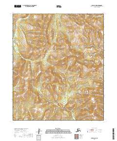
2019 Map of Ruby D-6 NE
USGS Topo · Published 2019About this map
Highland ridges and glacial valleys define this interior wilderness within the t6s r16e and t7s r16e land divisions. The terrain is structured by subtle watercourses that carve through the landscape, most notably Fox Cr in the northern reaches and Grayling Cr in the southwest. This 2019 survey, produced using data from the National Elevation Dataset and GNIS, provides a clear view of the complex topography where no established roads or permanent settlements were recorded at the time of mapping. The absence of infrastructure highlights the isolation of this sector in the Yukon-Koyukuk region, where land management is divided between various public and private interests across the t6s r15e and t7s r17e townships.
Find a feature on this map
8 named features on this map. Tap any name to fly to it.
Don’t see what you’re looking for? This feature index may not catch every label — zoom into the map to look around manually.
Map Details
Editions of this 2019 Ruby D-6 NE Map
This is the sole edition of this map. No revisions or reprints were ever made.
Other maps of this area

1951 · Ruby
USGS Topo · 1:250,000

1951 · Melozitna
USGS Topo · 1:250,000

1952 · Ruby D-6
USGS Topo · 1:63,360

1952 · Ruby D-5
USGS Topo · 1:63,360
1952 · Melozitna A-6
USGS Topo · 1:63,360

1952 · Ruby
USGS Topo · 1:250,000
1954 · Melozitna A-5
USGS Topo · 1:63,360

1956 · Melozitna
USGS Topo · 1:250,000

1964 · Ruby
USGS Topo · 1:250,000
2016 · Melozitna A-6 SW
USGS Topo · 1:25,000